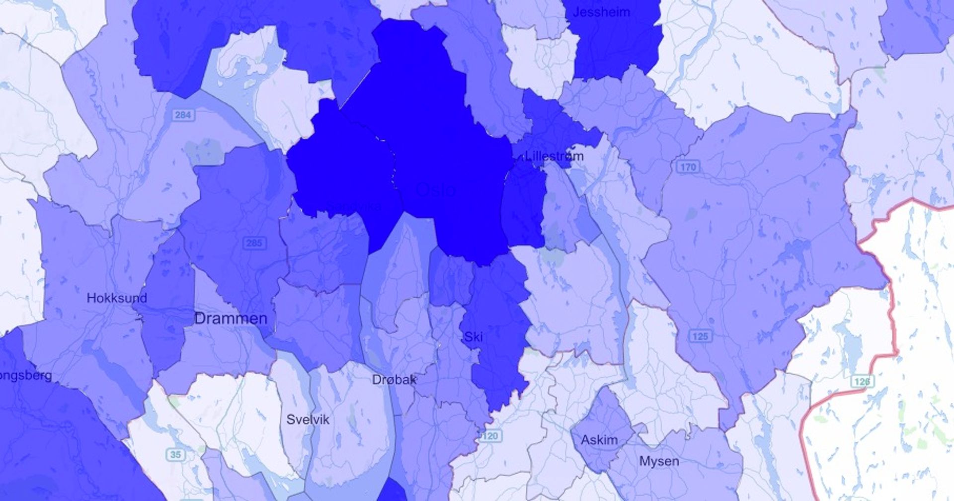
So the other day, while googling for a simple plot-some-data-on-a-map solution, I accidentally stumbled upon a gist with a map inside and had to stop to investigate this further. I found that gist are automatically rendering maps when you insert/upload topojson data. Ok great, let's try to use this for something fun... ## TL;DR If you are in a hurry and just want to test this without reading all the text. Here is the short howto list, or you can view my crud [US president election 2016 poll hack](https://gist.github.com/5orenso/2f6649307d3bdfc672450ffd54ffd3ed) made with the same method. 1. [Municipalities in Norway as geojson](http://data.kartverket.no/download/content/administrative-enheter-norge-wgs-84-hele-landet-geojson) 2. [Employed people in all municipalities in Norway](https://www.ssb.no/statistikkbanken/SelectVarVal/Define.asp?MainTable=InntektStruk15&KortNavnWeb=ifhus&PLanguage=0&checked=true). 3. Do the command line magic: ```bash $ sudo npm install -g topojson $ topojson -o municipality.topojson -p navn,komm kommuner.geojson $ iconv -f iso-8859-1 -t utf-8 dataset.csv > dataset-utf8.csv $ git clone git@github.com:d812cb66ac9f6ff6b8bf01cf7dfe9f39.git $ cd d812cb66ac9f6ff6b8bf01cf7dfe9f39/ $ node ./topo-json-number-of-employed.js $ brew install gist $ export LC_ALL=en_US.UTF-8 $ export LANG=en_US.UTF-8 $ gist ``` 4. Done. Now click the link in your terminal and enjoy your beautiful map. ## TopoJSON Ok, so this is the place to start if you want to read about all the details. First let's find some useful tools for dealing with topojson. ### Install topojson To be able to handle topojson files you need a tool. Luckily this tool is called [TopoJSON](https://github.com/mbostock/topojson). With this tool you are able to convert files from geojson to topojson command line. To install this tool with npm: ```bash $ sudo npm install -g topojson ``` ### Find some useful map data I've chosen to download a geojson file with all the borders for all municipalities in Norway. You can download the data from Kartverket: [Municipalities in Norway as geojson](http://data.kartverket.no/download/content/administrative-enheter-norge-wgs-84-hele-landet-geojson) This is a rather big file, 24MB unzipped. Let's try to convert it to topojson with the command line tool we just installed. ```bash $ topojson -o municipality.topojson -p navn,komm kommuner.geojson ``` Yay! Now my file is only 0.77MB and much more useable for web pages and mobile devices. ### Enrich map data with some insight I found a data set containing [a count of all employed people in all municipalities in Norway](https://www.ssb.no/statistikkbanken/SelectVarVal/Define.asp?MainTable=InntektStruk15&KortNavnWeb=ifhus&PLanguage=0&checked=true). These dataset are mainly encoded randomly (most of them are iso-8859-1), so you need to verify the encoding before you proceed. ```bash $ file -I dataset.csv ``` If you get something other than `utf-8` you need to convert to `utf-8`. ```bash $ iconv -f iso-8859-1 -t utf-8 dataset.csv > dataset-utf8.csv ``` ### Merging datasets To merge the topojson with the other dataset you need to write some lines of code. It's not too hard but I can give you a flying start with my hack. Don't shoot me for the lack of testing and other best practices. [5orenso/topo-json-number-of-employed.js](https://gist.github.com/5orenso/d812cb66ac9f6ff6b8bf01cf7dfe9f39) ### Upload the file to a gist To be able to get the topojson file into a gist without having to copy-paste it you need a tool. As far as I know, it's not possible to upload files in the gist webinterface, so I found a nice tool for uploading files to a gist on the command line. This tools is called `Gist`. To install the tool you do like this. ```bash $ brew install gist ``` And if you environment encoding is wrong you need to set this before running it. If you have the wrong environment setting you will probably get a nasty error like the one I got: `Error: "\xC3" on US-ASCII`. ```bash $ export LC_ALL=en_US.UTF-8 $ export LANG=en_US.UTF-8 ``` To upload the new topojson file you just type. ```bash $ gist ``` Cmd + click the new link to see your shiny new gist. Mine looks like this: _There are some mapping issues for some of the municipalities, but I haven't bothered to fix them yet. Maybe later... or if you want to help me, give me a shoutout on Twitter [@sorenso](https://twitter.com/sorenso)_ [5orenso/municipality-enriched-2014.topojson](https://gist.github.com/5orenso/cb57f9ae08b3ecdc19038d5de2899aaf) 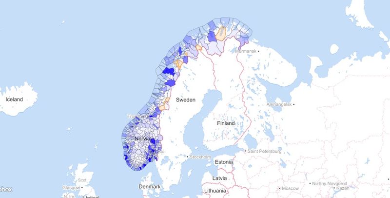 Happy gisting :-)